 Guide On Map
Canals and Merchants of Hanseatic Bruges
From Jan van Eyckplein along Spiegelrei and the northern canals to Oude Beursplein
Guide On Map on your phone
Open the walk like a regular app
It takes about 10 seconds to install. No app store needed.
The whole path
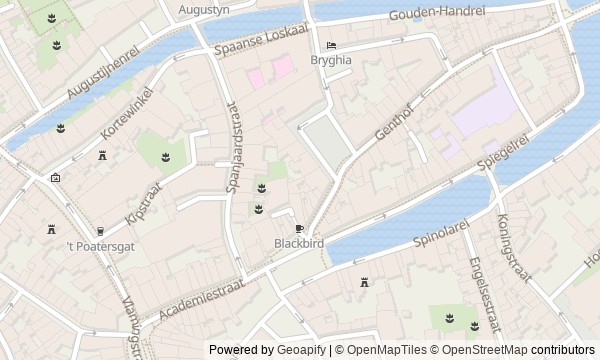
Route map
About the walk
You will begin at Jan van Eyckplein, where the former harbor lies beneath the cobblestones and the houses of those who received goods and merchants rise around you. The route then runs from Poortersloge and the customs house along Spiegelrei to the northern canals, across stone bridges, before returning to the tight corner of the old exchange.
This is not a walk through postcard Bruges, but a route through the backstage of its trade. You will encounter a coat of arms that was supposed to be yielded to the next winner; barrels of butter over which two cities argued; water already set aside on a plan for a theater; a hand holding an eel on a keystone; and a bridge paid for without any guarantee that it would be allowed to remain.
The story will separate documents from local legend and test grand words against small expenses, work, and risk. After the walk, you will read this corner of Bruges as a port: through warehouse gates, a weighing office, bridges, and the surname that became the name of an exchange.
Why this order
Jan van Eyckplein first offers a full view of the former harbor. Poortersloge and Tolhuis opposite it then divide the two sides of its life: the standing of merchants and the movement of goods. From the customs house, the surviving Spiegelrei leads to Koningsbrug, where the history of trade gives way to a dispute over what the city intended to do with the water itself. Farther on, the bend in the canal brings you to Gouden-Handrei: after the construction project that never happened, the bridge's name becomes tied to local legend instead. The same waterway continues to Augustijnenbrug and shows why the neighboring monastery needed a crossing of its own. From the bridge, Spanjaardstraat returns you to the old harbor, while Academiestraat leads to the national houses and Ter Beurze, where a cargo's journey ended in a meeting of merchants and a financial deal.
Those interested in Bruges as a trading city, not just a postcard Those who enjoy short human stories inside a larger economy Those who want to walk beside the less crowded northern canals
Those expecting a route through the main cathedrals and museum halls Those primarily looking for panoramic views and famous photo spots Those who do not enjoy stories about tolls, city rights, and trading customs
Before you go
The entire route is on foot and covers about 1.1 km, but allow time for stops by the water and a close look at the upper parts of the facades. Most of the story is experienced outdoors; access to Poortersloge depends on the current exhibition program, so check separately if you want to visit the interior. Wear sturdy shoes for the bridges and cobbled quays: stone can be slippery after rain. Do not stand in narrow passages or in the roadway while looking at high details or listening to the audio.
When to go
Choose daylight hours. In the morning, it is usually easier to stop along the quays and study the reflections; toward evening, the brick and water become more expressive.
Backup plan
If rain, wind, or crowds make it hard to linger by the canals, shorten the listening stops on open bridges and move your pauses to sheltered spots by facades, without blocking entrances. A closed Poortersloge does not break the route: the bear, tower, niches, and traces of later Neo-Gothic work remain visible from outside. If the paving is slippery, do not go down to the water's edge or try to retrace historic approaches to the quays—all key details can be seen from the regular pedestrian level. The route is compact, so any missed stop is easy to revisit on a short loop after the finish.
Route conditions
Surface. Paved — 963 m (data covers 84% of the route)
Facilities. Toilets — 1; drinking water — 2
Elevation. Ascent — 5 m; descent — 2 m
OpenStreetMap extract of June 18, 2026: database data, not a check on the ground. Data © OpenStreetMap contributors, ODbL licence
Walk plan
Open in maps ↗- 1
Jan van Eyckplein
Here, a filled-in harbor and a city program that reshaped Bruges’s familiar appearance come together. - 2
Poortersloge
This stop will show how a tournament victory turned into a year of civic duties. - 3
Tolhuis / Former Customs House
Using one consignment of butter as an example, this stop shows who had the right to city work and its pay. - 4
Koningsbrug and Spiegelrei
The surviving water makes it possible to see an unrealized urban construction project at its true scale. - 5
Gouden-Handrei and Gouden-Handreibrug
The bridge brings together the documentary name of the place and the legend carved in stone. - 6
Augustijnenrei and Augustijnenbrug
The crossing will show what the monastery risked for a direct route to townspeople and merchants. - 7
Oude Beursplein and the Nation Houses
The final stop connects an inn, the representative offices of foreign merchants, and the European name for trading.
Route features
Everything you need stays in the browser
Progress, saves and your trip plan are stored on this device.
Add Guide On Map to your home screen so the walk opens outside the browser.
How we handle sources, maps and corrections: our editorial standards