 Guide On Map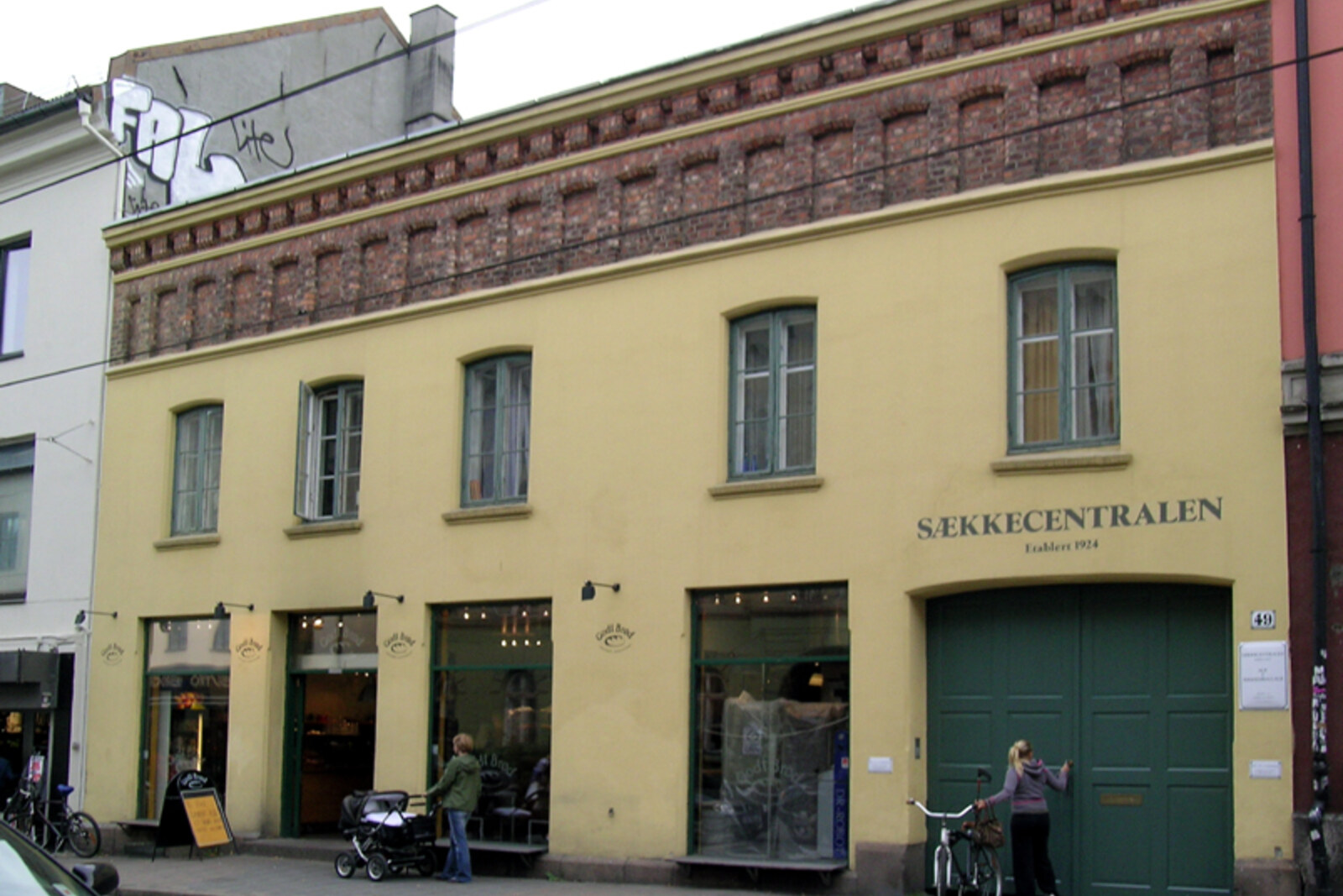
Look around first
What to notice
- Tram tracks
- Brick rental apartment buildings
- Shops on the ground floors
- The façade of house No. 49
The story of the place
Trams run down the middle of a broad city street, with brick façades and shops on the lower floors stretching along both sides of the tracks. When the neighborhood was developed, businesses were kept closer to Akerselva, while land along this road was set aside for a school, a church, and green spaces. At first, a horse tram ran here, and its terminus stood by house number forty-nine. Behind its façade, the former stables and tramcar shed still survive.
The street signs bear the name of Thorvald Meyer, a wholesale merchant and landowner who was to turn the nearly empty Grünerløkka into urban lots suitable for sale.
Meyer made his fortune through trade and timber. He transported goods from London and Hamburg on his own ships, and owned forest land and sawmills. These revenues allowed him to keep money tied up in land for years. In the early eighteen sixties, he and a partner bought most of the undeveloped land between Akerselva and the city outskirts. There were almost no buyers for the lots, so Meyer began waiting for Kristiania to grow in this direction.
But waiting alone was not enough. Meyer commissioned a plan for the blocks and paid out of his own pocket for the initial construction of a broad longitudinal road. In documents, it was first called April Twenty-Fifth, Eighteen Sixty-One Street. In eighteen sixty-four, a city commission replaced this bureaucratic name with that of the man whose money was being used to lay the road.
Meyer sold the land, but did not let its fate out of his hands. In the contracts, he retained the right to approve the façades of future houses, and on some lots he prohibited factories. He conveyed land for public buildings and green spaces to the city free of charge. This is how residential blocks, a school, a church, and parks appeared along one street, while businesses remained closer to the river.
The calculation paid off. By eighteen sixty-nine, Meyer had become the sole owner of the land that had been purchased. Just five years later, he received forty times more for individual lots than the price he himself had paid for the land. Buyers developed them with brick rental apartment buildings; by the end of the century, more than twenty thousand people already lived in Grünerløkka.
For these residents, the transport company laid a horse-tram line along the street in eighteen seventy-eight. Its terminus was located by house number forty-nine. The courtyard held fifty-five horses, nine tramcars, a forge, and housing for the coachmen and their families. When the horse tram was replaced by an electric tram, the tracks remained on the same route.
Modern trams still run down the middle of the street, shops occupy the ground floors of the buildings, and behind the façade of number forty-nine, the former stables and tramcar shed have survived. Meyer's name remained on the road that he paid for so that he could sell land on both sides of it.
Useful on site
The street is accessible around the clock; shops and cafés operate on their own schedules.
Checked: June 17, 2026. Check the official source before visiting.View the buildings from the sidewalk and do not try to enter residential entryways; the numbers matter as points in history, not as places to visit.