 Guide On Map
Fort Point and Seaport: Warehouses, Museums, and Piers
From Boston Tea Party Ships & Museum through Fort Point to Pier 4
Guide On Map on your phone
Open the walk like a regular app
It takes about 10 seconds to install. No app store needed.
The whole path
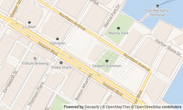
Route map
About the walk
You will walk from reconstructed tea ships across Fort Point Channel and past brick warehouses to Seaport's open waterfront. At first, the route will feel tight and industrial: the steel frame of a bridge, freight facades, a converted warehouse. Then come a lawn, floating docks, a museum cantilever, and new homes by Pier 4.
The story follows the remaking of the waterfront. People will fill in flats, lay rail tracks out to ships, move into empty warehouses, and press for access along private development. But the real hooks are in the details. Why will the people who destroyed the tea replace a single broken lock? How will a wooden bottle arrive at a museum before the museum itself? Why will a restaurant owner first feed the city's taxi drivers?
The approach will be calm and concrete. By the end, you will be able to read this Boston waterfront through the terms of its reinvention: where authorities preserve access to the water, what developers put in place of rail tracks, and why an old pier number outlives both a restaurant and a steamship.
Why this order
Boston Tea Party Ships & Museum sets the starting point by the water, while the neighboring Congress Street Bridge explains how the channel was connected to the future industrial district. Cross the bridge and you arrive among the warehouses the crossing was built for; their later history leads from freight to artists. Next, Boston Children's Museum shows another way to occupy an old warehouse, while the bottle at its entrance adds the story of a rescued roadside building. From the channel, the route reaches Fan Pier, where freight tracks gave way to a park and docks. The park leads to Institute of Contemporary Art / Boston, the key cultural building of the new development. From there, Harborwalk continues to Pier 4, where the public path winds around private homes and concludes the story where a restaurant and a steamship disappeared.
Those who love industrial architecture and waterfronts Those interested in urban reinvention and the fates of old buildings Those who prefer human decisions to grand history
Those looking for a walk only through colonial Boston Those who want museum interiors rather than a city route Those who do not enjoy open waterfronts and contemporary development
Before you go
The main route stays outdoors, so tickets for Boston Tea Party Ships & Museum, Boston Children's Museum, and Institute of Contemporary Art / Boston are needed only if you plan to go inside; check visiting conditions separately before setting out. In Fort Point, temporary barriers and changed paths are possible because of street work—follow current signs rather than the side of the street you may be used to. Wear shoes suitable for brick, boardwalks, and a wet waterfront. The open harbor is usually noticeably cooler and windier than the warehouse streets, so an extra layer will come in handy even on a clear day.
When to go
Allow about two hours for the outdoor route of roughly 1.6 kilometers: the stories here are noticeably longer than the walks between stops. A visit to one museum can easily add several hours; if you want to take in every stop carefully, it is better to save two museum visits for a separate day.
Backup plan
In rain or strong wind, take the compact first section: the ships, bridge, nearby warehouse streets, and Hood Milk Bottle can be linked without long pauses by the open harbor. Then, if you wish, take shelter in one museum chosen in advance. If the boardwalks are icy or water is spilling over the edge, do not continue right along the waterfront: end the walk at the exterior of Institute of Contemporary Art / Boston. Save Fan Pier and Pier 4 for a day when you can safely linger by the water and clearly see how the waterfront is laid out.
Route conditions
Surface. Paved — 473 m (data covers 30% of the route)
Facilities. Toilets — 1; drinking water — 3
Elevation. Ascent — 4 m; descent — 7 m
OpenStreetMap extract of June 18, 2026: database data, not a check on the ground. Data © OpenStreetMap contributors, ODbL licence
Walk plan
Open in maps ↗- 1
Boston Tea Party Ships & Museum
Here, a dispute over a duty will turn into a collective action whose participants will protect other people's ships more carefully than their own peace of mind. - 2
Congress Street Bridge
The bridge explains how access across the channel turned filled mudflats into an industrial district. - 3
Fort Point Warehouses
This stop will show why an affordable studio required its owners to give up part of their future profit in advance. - 4
Boston Children's Museum and the Milk Bottle
A roadside shop found by chance will connect the museum's move with a new idea for children's exhibits. - 5
Fan Pier Park
The park will take the place of a vanished rail terminal, of which only the name, hinting at the shape of the tracks, will remain. - 6
Institute of Contemporary Art / Boston
The building will show what exchange among the museum, the developers, and the city made it possible to preserve a public place by the water. - 7
Harborwalk at Pier Four
The finale brings together a successful restaurant, a capsized steamboat, and today’s path alongside private homes.
Route features
Everything you need stays in the browser
Progress, saves and your trip plan are stored on this device.
Add Guide On Map to your home screen so the walk opens outside the browser.
How we handle sources, maps and corrections: our editorial standards