 Guide On Map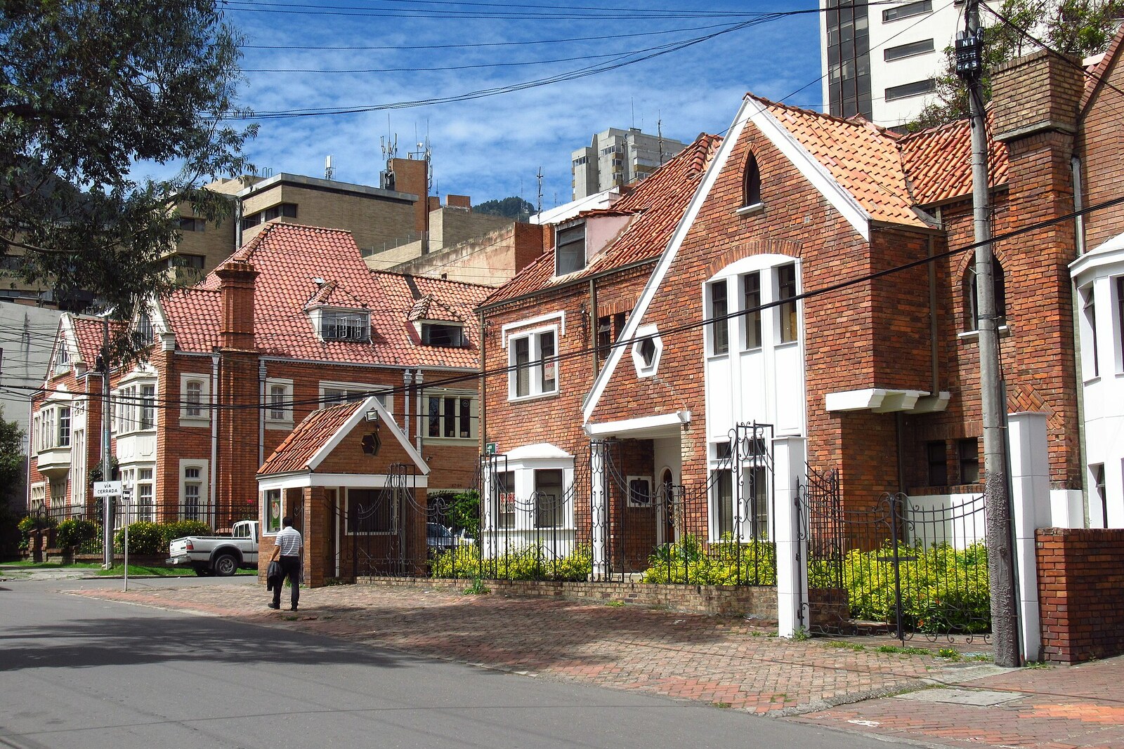
Look around first
What to notice
- Brick façades
- Steep roofs
- Projecting bay windows
- Front gardens
The story of the place
Behind the brick façades with steep roofs and bay windows, gardens stretch out, separating the houses from the street. The neighborhood was planned as an expensive residential development: large plots held one two-story house, with the ground floor reserved for entertaining and the upper floor for family life. Its overall silhouette was maintained not by a single project: each family built its own house, but followed the same restrictions on plot size, height, and front gardens. When cafés, schools, offices, and banks arrived, protected status preserved the exterior appearance, although the interior rooms changed along with the city.
The name Quinta Camacho remains from the Camacho family’s country estate. Here, “quinta” means a large house with land beyond what was then the city limits. The house of Enrique Camacho Leyva and Rebeca Gutiérrez stood near the corner of Carrera 13 and Calle Sixty-Eight, amid about thirteen hectares of pines, eucalyptus trees, and undeveloped plots.
After the inheritance was divided in nineteen twenty-eight, the land went to their sons Pedro, Domingo, and Francisco Camacho Gutiérrez. The family estate was their capital. According to an old Bogotá chronicle, Enrique once paid two centavos per square vara for the land—a square vara is slightly smaller than a square meter. Now the brothers had to make money from their father’s purchase by turning the estate into urban plots.
In December nineteen thirty, they submitted the first neighborhood plan to the municipality. Four years went into revisions and approvals. The regulations approved by the brothers determined even what kind of person would be able to settle here. On the main streets, a plot had to cover at least five hundred six square meters and face the street with a frontage at least twenty meters wide. One residential house, up to two stories high, was allowed on it. A front garden was required before every house, and commerce was limited to shops needed by the residents themselves. Each owner arranged a water contract separately.
Such a plot was affordable to a buyer who could hire an architect or a construction firm. The brothers sold the land for more, while the new owners received spacious homes with separate rooms for entertaining on the ground floor and family life upstairs.
The neighborhood’s English appearance also grew out of a practical decision. Bogotá architects and engineers used British building albums. Martínez y Hoyos acquired the book “Tudor Homes of England,” published in nineteen twenty-nine, and adapted its details to local commissions. Following these models, builders repeated steep roofs, brick façades, projecting bay windows, and brick-built chimneys. The houses did not become identical: each one was commissioned by a different family. Their overall appearance was maintained by the plot sizes, height, and set of details written into the heirs’ regulations.
The residential order began to change in the nineteen sixties, when shops began opening near Avenida Chile, followed by banks and offices. It became more profitable for owners of large houses to rent them to institutions and restaurants. In nineteen seventy-nine, the city included the neighborhood in a protected zone, so many owners adapted the rooms inside while preserving the brick façades, roofs, and front gardens.
The estate that gave the neighborhood its name stood closer to Carrera 13 and Calle Sixty-Eight. The brick houses farther into the neighborhood appeared on the subdivided Camacho land. Above today’s restaurants, cafés, schools, and offices, the terms on which Pedro, Domingo, and Francisco sold the family inheritance can still be read: one large house on a plot, two stories, and a garden before the façade.
Useful on site
Open residential/business district; respect private homes and office entrances.
Checked: June 28, 2026. Check the official source before visiting.View the houses from the street and respect private property: many buildings remain homes or are occupied by institutions. Do not enter courtyards for a photograph.