 Guide On Map
Getsemaní: A Neighborhood of Artisans and Neighbors
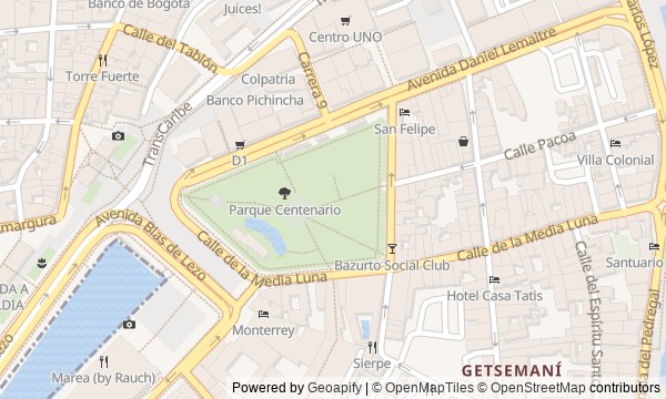
From Camellón de los Mártires through Calle de la Media Luna to Calle del Pozo
Guide On Map on your phone
Open the walk like a regular app
It takes about 10 seconds to install. No app store needed.
The whole path
Route map
About the walk
You will begin at the edge of the old city, between white busts and an anniversary park. Two questions appear right away: why are there more portraits than executions, and whose monument were the artisans never able to raise? Then the route turns into Getsemaní along Calle de la Media Luna, a commercial street named for a vanished fortification. You will walk from the former gate to Plaza de la Trinidad, its church, a narrow alley beneath umbrellas, and the site of a shared well. The story rests not on ceremonial heroes, but on the actions of artisans, soldiers, parishioners, and neighbors. It separates the documents from later memory and shows how major decisions changed ordinary courtyards and streets. By the end, you will read Getsemaní not as a colorful backdrop to fortified Cartagena, but as a neighborhood where residents repeatedly claimed the right to gather, worship, work, and play close to home.
Why this order
Camellón de los Mártires sets out the official memory of independence, while the neighboring park immediately shows who the anniversary version left out. From the park, Calle de la Media Luna follows the former road to the only land entrance, making clear how the city's boundary shaped the outcome of the siege. The route then enters residential Getsemaní: Plaza de la Trinidad shows where residents set out to pressure the Provincial Junta of Cartagena, while the church on the square reveals how the neighborhood fought for its own religious life. From the large square, the way narrows into Callejón Angosto, where neighbors reclaimed shared space once again. The alley leads to Calle del Pozo, where the finale connects today's street gatherings with an older place of shared work and water.
Those who want to see Cartagena beyond the fortified postcard Those interested in the history of artisans and the urban working classes Those who enjoy connecting monuments with everyday neighborhood life
Those expecting a walk only through the main palaces and cathedrals Those uninterested in political disputes and public memory Those who prefer a route without busy squares and narrow streets
Before you go
Plan to spend most of the route outdoors: the church is an active parish, so access inside may depend on services and local life. Dress and behave appropriately for a place of worship. In the alleys, do not look through open doorways, occupy residents' steps, or photograph people without asking permission. In the park, watch animals from a distance: do not touch or feed them, even if someone offers contact for money. Bring water and sun protection, as there is not shade along the whole route.
When to go
Start in the morning for quieter streets, or closer to the end of the day, when the heat eases and Plaza de la Trinidad gradually fills with evening life. The midday heat makes the open stretches noticeably harder, while late evening makes monuments and facade details more difficult to see.
Backup plan
If the park is temporarily closed or entering it is inconvenient, view its greenery, fence, and obelisk from outside, then continue to Calle de la Media Luna. During a service or if the church door is closed, do not try to enter: you can listen to the story in front of the facade. If Plaza de la Trinidad is overcrowded, step away from the center of the square, move the longer pause to the next stop, and return later. In rain, shelter in an accessible public place, do not use private entrances, and take particular care on wet narrow streets.
Route conditions
Surface. Paved — 1 km (data covers 70% of the route)
Facilities. Toilets — 1
Elevation. Ascent — 7 m; descent — 4 m
OpenStreetMap extract of June 18, 2026: database data, not a check on the ground. Data © OpenStreetMap contributors, ODbL licence
Walk plan
Open in maps ↗- 1
Camellón de los Mártires
Here, the official memorial line begins with a mismatch between the number of people executed and the number of portraits. - 2
Parque del Centenario
The park shows how an anniversary monument and the artisans' contribution diverged over the choice of the main hero. - 3
Calle de la Media Luna
A vanished fortification makes it possible to examine a military maneuver in which an unsuccessful assault achieved its purpose. - 4
Plaza de la Trinidad
The square is needed to move the story of independence from the meeting hall to the people gathered before marching on the junta. - 5
Iglesia de la Santísima Trinidad
The church shows the price the residents paid for their own church and which right its donor did not receive. - 6
Callejón Angosto
The alley will connect the old dense development with the neighbors’ recent attempt to make the street shared again. - 7
Calle del Pozo
The final stop explains the shape of the square through the vanished shared source of water for household use.
Route features
Everything you need stays in the browser
Progress, saves and your trip plan are stored on this device.
Add Guide On Map to your home screen so the walk opens outside the browser.
How we handle sources, maps and corrections: our editorial standards